The DARKERSKY4CE project has taken a new step in the fight against light pollution with the creation of an interactive GIS map. Developed by the South Transdanubian Regional Innovation Agency (STRIA) and published by the project Repository, this digital tool is reshaping how we understand, visualize, and protect the natural night across Central Europe.
A Map with a mission
Light pollution is more than a nuisance—it’s a growing environmental challenge that affects wildlife, ecosystems, and even our cultural connection to the stars. The Darkersky4CE map brings this invisible issue into focus by integrating data on light intensity, biodiversity, and land use to show where darkness—and the life that depends on it—is most at risk.
This map serves as a decision-support tool for policymakers, planners, and environmental managers. By overlaying light pollution levels with information about ecosystem services such as biodiversity, carbon storage, water regulation, and cultural or recreational value, it helps identify priority areas for conservation and sustainable development. For example, regions with sensitive habitats or dark sky parks can be protected through targeted planning measures and adapted lighting regulations.
From pilot sites to a continental vision
Initially, partners focused on mapping pilot areas in six project countries: Italy, Austria, Germany, Hungary, Poland, and Slovenia. As the project evolved, partners realized the potential to expand the tool’s coverage, eventually including all countries of the Interreg Central Europe programme, including the Czech Republic to Croatia and Slovakia.
Today, the Darkersky4CE GIS map, in continuous development, provides a comprehensive view of light pollution and ecological values across Central Europe, offering a shared platform for cross-border collaboration and long-term strategic planning.
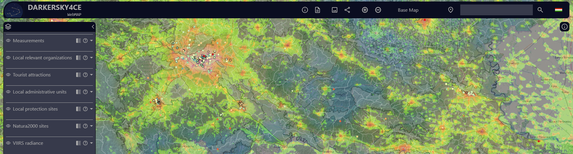
What’s inside the map
The GIS tool is built around several interactive data layers, each offering a unique perspective on the relationship between artificial light and natural systems. These include several datas from local administrative units, to allow analysis at the municipal level; Light pollution data, including real measurements from SQM sensors and satellite-based VIIRS radiance data;
Protected areas, such as Natura 2000 sites and national parks, where dark-sky protection is a priority; Ecosystem service indicators, visualized through land cover and natural landscape data; Tourism and dark sky initiatives, linking environmental protection with sustainable economic opportunities.
All data come from open and reliable sources such as the European Environment Agency, Eurostat, and the Lightpollutionmap.info platform. STRIA also integrated results from citizen science projects like Globe at Night, combining professional and community-based data in one dynamic visual environment.
Supporting knowledge and action
The visual and user-friendly nature of the map makes it not only a scientific resource but also an educational and engagement tool. Local authorities can identify areas suitable for dark sky park designation, while tourism operators can highlight destinations where stargazing and nature coexist. The public can explore how their region fares in terms of light pollution and understand the link between natural darkness, biodiversity, and quality of life.
A built-in reporting tool allows users to generate customized summaries by municipality, including local population data, sky brightness levels, land cover types, and protected area information. This function helps transform data into concrete insights for better planning and management decisions.
A foundation for the future
While the current version of the map uses static datasets, partners have ensured that it can be updated over time as new measurements become available. The ultimate goal is to maintain an evolving digital platform that supports ongoing research, monitoring, and policymaking in the field of light pollution and ecosystem conservation.
By combining cutting-edge mapping technology with environmental awareness, the DARKERSKY4CE GIS map brings us closer to a vision where darkness is not lost, but valued, as a vital part of Europe’s natural heritage and sustainable future.